Blog

  • Planning a hike in Picos de Europa

    Pico Urriellu mountain peak
    Evölah, CC BY-SA 3.0 https://creativecommons.org/licenses/by-sa/3.0, via Wikimedia Commons

    Research Guide: Hiking Logistics for Picos de Europa

    The Picos de Europa National Park, spanning Asturias, Cantabria, and Castile and León, presents a highly technical and demanding mountain environment. Known for its steep limestone massifs and deep gorges, the park offers routes ranging from rigorous multi-day alpine circuits to well-maintained valley trails. The following guide details the logistical requirements for trekking in Spain’s oldest national park.

    1. Transportation and Access

    Accessing the high-altitude trailheads requires utilizing a combination of rail, long-distance coaches, and local shuttle systems. The primary long-distance provider is the ALSA coach network.

    If arriving via Bilbao airport, travelers can utilize an ALSA bus to reach Unquera (an approximate 3-hour journey with coastal stops). From Unquera, regional bus connections are available via Jimenez Movilidad to the southern hub of Potes (1 hour and 10 minutes), or toward the northern gateway via a local bus to Arenas de Cabrales. These public transit options provide cost-effective alternatives to private taxi hires.

    2. Trail Networks and Difficulty Levels

    The terrain is characterized by steep elevation changes. A prominent multi-day route is the Anillo de Picos (Ring of Peaks), which is divided into three distinct circuits:

    • Anillo Vindio (Moderate-High): A 63 km circuit through the Western Massif, typically taking 4 days. It involves navigating the park’s characteristic limestone gullies (“canales”).
    • Anillo Extrem (High): An 82 km route across the West and Central massifs, featuring substantial elevation gain (totaling approximately 7,050m).
    • Anillo Tres Macizos (Expert): A 115 km circuit covering all three massifs. This route traverses sharp karst pavement and requires over 9,000m of total climbing.

    For hikers seeking an accessible day trek with minimal elevation gain, the Ruta del Cares offers a 12km maintenance track carved directly into the cliffs separating Poncebos and Caín.

    3. Accommodation: Refugios and Bivouacking Regulations

    The park utilizes a network of high-altitude mountain refugios that serve as critical safety and logistical hubs. Advanced booking is strictly required, particularly during the summer season, and must be done through the official centralized portal, Reserva Refugios. Individual huts, such as the Refugio Vega de Ario, offer up-to-date regional trail conditions. Half-board reservations (approximately 45€) are highly recommended, as walk-in dinner requests are frequently denied due to limited supplies.

    Bivouacking Policies: Traditional wild camping is strictly prohibited and subject to fines. However, there is a legal exception for pernocta (bivouacking). Tents may be pitched if the hiker is above 1,600 meters in elevation, provided the tent is erected no earlier than one hour before sunset and dismantled within one hour after sunrise.

    4. Weather and Trail Conditions

    Due to the park’s proximity to the Cantabrian Sea, weather conditions are highly variable and subject to rapid shifts. The optimal trekking window is typically September for stable weather, or May through June for flora, although snowfields can persist at higher elevations well into July.

    Hikers must be prepared for the encainada—a rapid, dense sea mist that can reduce visibility to near zero within minutes. GPS navigation devices are strongly recommended due to the disorienting nature of the limestone karst landscape under these conditions. Below is a breakdown of average weather conditions throughout the year.

    5. Cultural and Historical Sites

    The region holds significant historical value regarding the Spanish Reconquista. The Sanctuary of Covadonga, located at the western edge of the park, features a holy cave and a neo-Romanesque basilica built into the cliffside.

    Within the Valdeón Valley, hikers can observe traditional Hórreos. These are ancient wooden granaries elevated on stone pillars, historically utilized to protect local agricultural yields from humidity and rodents.

    6. Key Geological and Natural Landmarks

    • Pico Urriellu (Naranjo de Bulnes): A prominent 2,519-meter limestone monolith located in the central massif.
    • Cares Gorge: A 1.5-kilometer-deep geological fissure separating the western and central massifs.
    • Lakes of Covadonga: Glacial lakes (Enol and Ercina) situated at 1,100 meters in elevation. Note that environmental regulations strictly prohibit camping in their immediate vicinity.
    • Torre de Horcados Rojos: A 2,503-meter peak that serves as a central vantage point for panoramic observation of the park.

    7. Reference Video Logs

    The following video logs provide practical visual references for the terrain, elevation gradients, and expected trail conditions:

  • Gran Canaria Hiking – Volcanic Landscapes

    The silhouettes of the central peaks — Gran Canaria

    Saturday, Feb 8: Arrival in Las Palmas

    One relaxed night in the city to settle in, eat well, and get ready to trade coastal streets for canyon trails. I enjoyed some tapas and was ready for my trek to begin.

    Tapas in Las Palmas—celebrating the arrival from Copenhagen before the trek.

    Sunday, Feb 9: Barranco del Toro

    Starting near Maspalomas, I headed north into the Barranco del Toro area, following the S-54 trail towards Fataga. This was a “dry” canyon hike—deep ravines, stark rock, and desert vegetation. I set up camp near Fataga.

    Monday, Feb 10: The Camino de Santiago (Tunte Ascent)

    A significant day of elevation gain. I started near Fataga and hiked north, passing San Bartolomé de Tirajana, walking a segment of the GR-138. I finished on a ridge near the Zona de Acampada Llanos de la Pez—with beautiful views toward El Nublo and the Atlantic.

    Tuesday, Feb 11: Tamadaba Ridges

    I moved from the Llanos de la Pez area into the northwest, exploring the high-altitude pine forests and ridges of Tamadaba Natural Park, also crossing Mirador de Cruz de Tejeda. Later I stopped in Artenara at Arte-Gaia for a nice dinner—possibly with a bit too much wine—and continued on to the Tamadaba Zona de Acampada, where I camped, with clear views across the ocean to Tenerife.

    Wednesday, Feb 12: The Trek to Güigüí

    The morning started with a hike from Tamadaba to Agaete via the S-90 trail—dewy forest first, then wide Atlantic views as the descent opened up. From Agaete, I took a bus to the trailhead for Playa de Güigüí. The final push was late, so it was dark by the time I arrived. The black sand beach felt impossibly remote under a star-lit sky.

    Thursday, Feb 13: Güigüí to Mogán

    After a night by the beach (and a swim in the Atlantic), I hiked back out and headed southeast. I caught a lift from a friendly German couple, restocked in Pueblo de Mogán, and continued toward the Zona de la Acampada Presa de las Niñas. Beautiful pasture lands—but I arrived at the campsite a bit late again.

    Friday, Feb 14: Central Peaks to Vega de San Mateo

    From the campsite I hiked to Ayacata. After a satisfying lunch at Restaurante Casa Melo, I caught a bus to Vega de San Mateo for the final night before heading home on the 15th.

  • A Few Seconds of Moonlight

    These images were made in near-darkness, using only the soft, directional light of the moon. Over a few seconds, the landscape gathers just enough light to reveal itself rendered in a way that feels both familiar and slightly unreal.

    These images were made in near-darkness, using only the soft, directional light of the moon. Over a few seconds, the landscape gathers just enough light to reveal itself—rocks, trees, water, and sky rendered in a way that feels both familiar and slightly unreal.

    Moonlit scene _RIV3157
    Moonlit scene _RIV3172
    Moonlit scene _RIV3184
    Moonlit scene _RIV3416
    Moonlit scene _RIV4255
    Moonlit scene _RIV4275
    Moonlit scene _RIV4290
    Moonlit scene _RIV4298-Pano
    Moonlit scene _RIV4325
    Moonlit scene _RIV4337

    ← Back to Home

  • Lycian Way – Turkey’s Ancient Coastal Trail

    Day 1: Exploring Antalya and getting ready

    Waking up in Antalya after a late flight, I spent the day exploring the narrow, sun-drenched alleys of Kaleiçi (the Old Quarter). Historically, this area is a living timeline: founded as Attaleia by the Pergamene King Attalus II in the 2nd century BC, it later became a major Roman port—marked by the grand marble arches of Hadrian’s Gate, still standing today. My exploration wasn’t just historical, though; it was a logistical puzzle.

    Since it was Sunday, March 24, which fell during the holy month of Ramadan, many smaller shops were shuttered. Finding a gas canister for my camping stove became an unexpected challenge. Eventually, my search led me to a building supplies store, the Banio Yapı Market Lara Şubesi, where I finally secured my fuel. With the gear complete and the sun setting behind the Seljuk-era Fluted Minaret, I settled into my second night at the Sunrise Hotel, a budget-friendly hotel I had booked for a surprisingly reasonable price.

    The view from the roof of the Sunrise hotel, over the bay of Antalya

    The view from the roof of the Sunrise hotel, over the bay of Antalya.

    Day 2: Onto the Lycian Way

    The second day began with a short walk to the bus station and a three-hour bus journey westward to Fethiye, a coastal hub that sits atop the ruins of ancient Telmessos. After a final supply run in Fethiye and a short walk, I reached the official wooden archway of the Likya Yolu (Lycian Way), marking the beginning of my trek. The path climbed steeply through pine-scented hills, offering sweeping views of the turquoise waters below.

    After a 6–7 hour hike, I set up camp in the mountains overlooking Kelebekler Vadisi (Butterfly Valley). As night fell over the Mediterranean, the isolation of the hillside was punctuated by the rhythmic, hauntingly beautiful sound of the Ezan (call to prayer) drifting up from the village mosques in the valley below, as I fell asleep tucked away in my tent.

    A yellow signpost on a cliffside pointing toward different sections of the trail, overlooking the turquoise waters of Ölüdeniz bay

    A yellow signpost on a cliffside pointing toward different sections of the trail, overlooking the turquoise waters of Ölüdeniz bay.

    The Landscape of Contrasts

    The Lycian Way presents an extraordinary variety of landscapes. One day you might be climbing steep mountain passes through fragrant pine forests, the next walking along pristine beaches with turquoise waters. The trail takes you through rugged coastal mountains, hidden coves, fertile valleys, and charming traditional villages.

    One of the most memorable sections is the climb to Mount Olympos (Tahtalı Dağı), where at 2,365 meters, you’re rewarded with panoramic views of the entire Mediterranean coast. On clear days, you can see from Rhodes in the west to Antalya in the east. The diversity of flora and fauna along the trail is remarkable, with endemic species found nowhere else in the world.

    View from Mount Olympos summit

    Trail Highlights

    The journey begins in Fethiye, a charming coastal town with a beautiful harbor. From there, the trail winds its way through some of Turkey’s most spectacular scenery:

    Butterfly Valley: A hidden paradise accessible only by boat or a challenging descent, home to over 100 butterfly species.

    Kabak Bay: A stunning secluded beach surrounded by dramatic cliffs, offering some of the best camping spots along the trail.

    Patara: Home to one of Turkey’s longest beaches and the birthplace of St. Nicholas (Santa Claus).

    Kalkan: A picturesque town with whitewashed houses cascading down to a beautiful harbor.

    Kaş: A vibrant town known for its crystal-clear waters and excellent diving spots.

    Olympos: An ancient city scattered through a forested valley, leading to a beautiful beach.

    The Cultural Experience

    What truly sets the Lycian Way apart is the opportunity to experience authentic Turkish culture. The trail passes through numerous small villages where time seems to stand still. Here, you’ll encounter warm hospitality, with locals often inviting hikers for tea or sharing stories about their region.

    The cuisine along the trail is a highlight in itself. Fresh seafood, olive oil, local cheeses, and seasonal vegetables feature prominently in the traditional Turkish diet. Many small pensions and guesthouses offer home-cooked meals that showcase the best of Mediterranean Turkish cooking.

    Traditional Turkish breakfast with village view

    Practical Considerations

    The Lycian Way is typically hiked between April and June or September and October when the weather is most favorable. Summer temperatures can be extreme, especially in the coastal sections. The trail is well-marked with red and white waymarkers, but having a good map and GPS is recommended.

    Accommodation ranges from camping and basic pensions to comfortable hotels in the larger towns. Water sources are generally reliable, but carrying a filter is advisable. The terrain can be challenging, with steep ascents and descents, so good physical fitness is essential.

    Photographic Opportunities

    For photographers, the Lycian Way is paradise. The golden hour light on the Mediterranean coast is simply magical. Ancient ruins against dramatic backdrops, traditional village life, and stunning landscapes provide endless opportunities for compelling images.

    Some of the best photographic moments include sunrise over the sea from high mountain passes, the warm glow of sunset on ancient stone walls, and the vibrant colors of local markets. The interplay between ancient history and natural beauty creates a unique visual narrative that’s hard to find anywhere else.

    Reflections

    Completing the Lycian Way is more than just a physical achievement; it’s a journey through time and culture. The trail teaches patience, resilience, and appreciation for both natural beauty and human history. Each day brings new discoveries, whether it’s a hidden beach, a perfectly preserved ruin, or a meaningful conversation with a local.

    The Lycian Way reminds us that the most rewarding journeys are those that engage not just our bodies, but our minds and spirits as well. It’s a trail that stays with you long after you’ve returned home, calling you back to its ancient paths and endless horizons.

    Final sunset on the Lycian Way
    ← Back to Home

    Day 1: Exploring Antalya and getting ready

    Waking up in Antalya after a late flight, I spent the day exploring the narrow, sun-drenched alleys of Kaleiçi (the Old Quarter). Historically, this area is a living timeline: founded as Attaleia by the Pergamene King Attalus II in the 2nd century BC, it later became a major Roman port—marked by the grand marble arches of Hadrian’s Gate, still standing today. My exploration wasn’t just historical, though; it was a logistical puzzle.

    Since it was Sunday, March 24, which fell during the holy month of Ramadan, many smaller shops were shuttered. Finding a gas canister for my camping stove became an unexpected challenge. Eventually, my search led me to a building supplies store, the Banio Yapı Market Lara Şubesi, where I finally secured my fuel. With the gear complete and the sun setting behind the Seljuk-era Fluted Minaret, I settled into my second night at the Sunrise Hotel, a budget-friendly hotel I had booked for a surprisingly reasonable price.

    The view from the roof of the Sunrise hotel, over the bay of Antalya.

    The view from the roof of the Sunrise hotel, overlooking the bay of Antalya before starting the trail.

    Day 2: Onto the Lycian Way

    The second day began with a short walk to the bus station and a three-hour bus journey westward to Fethiye, a coastal hub that sits atop the ruins of ancient Telmessos. After a final supply run in Fethiye and a short walk, I reached the official wooden archway of the Likya Yolu (Lycian Way), marking the beginning of my trek. The path climbed steeply through pine-scented hills, offering sweeping views of the turquoise waters below.

    After a 6–7 hour hike, I set up camp in the mountains overlooking Kelebekler Vadisi (Butterfly Valley). As night fell over the Mediterranean, the isolation of the hillside was punctuated by the rhythmic, hauntingly beautiful sound of the Ezan (call to prayer) drifting up from the village mosques in the valley below, as I fell asleep tucked away in my tent.

    A wide-angle view over sheer cliffs and the hazy blue expanse of the sea.

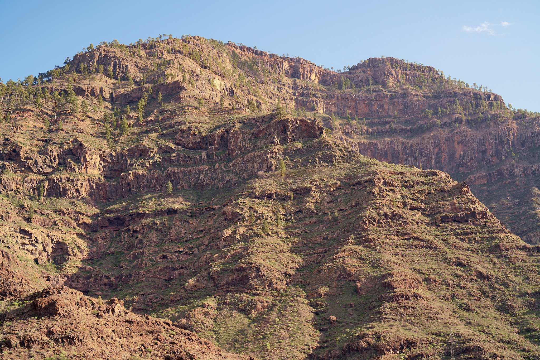
    A wide-angle landscape looking out over the sheer cliffs and the hazy blue expanse of the Mediterranean.

    Day 3: The Sunken Walls of Kalabantia

    I broke camp at first light, setting off just as the sun began to crest the ridges of the Taurus Mountains. By noon, the trail descended into the secluded bay of Kabak, a valley that has transitioned from a hidden hippy retreat to a gateway for trekkers. After a revitalizing swim in the azure waters and a quick ice cream to cut the midday heat, I pushed onward toward Cennet Beach (Paradise Beach).

    Ancient mule trail winding up into the hills above the sea.

    I followed this worn mule trail up into the hills; it doesn’t look like much, but it’s incredible to think it’s likely thousands of years old.

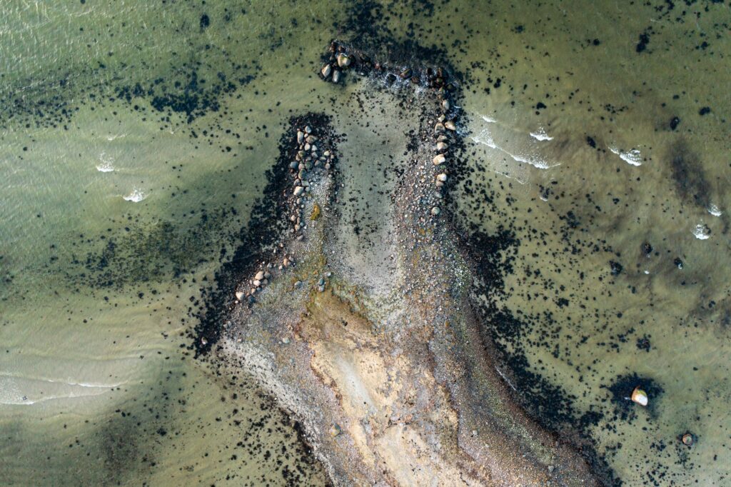
    The afternoon presented a navigational challenge; the Lycian Way is rugged, and a few obscured trail markers led me on a brief detour through the scrubland. Eventually I rejoined the trail, which led me to the day’s undisputed highlight: the ancient site near İzci Tepesi, known historically as Kalabantia. This was once a strategic Lycian port, and even today, you can see the massive, weathered stones of the ancient harbor walls stretching out into the turquoise surf like skeletal fingers.

    The Lycians were an independent maritime people, and Kalabantia likely served as a vital link for the Lycian League—the world’s first known democratic federation. After a swim among the ruins, I began the grueling ascent up a preserved ancient mule trail. The path, worn smooth by millennia of hooves and sandals, climbed steeply into the hills. After passing an old cistern, I eventually found a plateau to pitch my tent, perched high above the Mediterranean with a panoramic view of the coastline I had hiked.

    ← Back to Home
  • Lost Coast Trail – California’s Wilderness Coast

    The Lost Coast Trail is one of America’s most spectacular coastal hikes, offering a rare glimpse of California’s undeveloped wilderness coastline. Stretching 24.6 miles along the remote King Range, this trail takes you through a landscape so rugged that Highway 1 had to detour inland, leaving this stretch of coast truly “lost” to development.

  • Across the “Miniature Jotunheimen”: A Three-Day Trek Through Lifjell

    this is a test
    Starting the ascent through the lush green slopes on the first day of trekking.
    Reskjemvatn nestled in the forest valley, marking the transition to the high fell.
    A scenic waterfall encountered along the trail as we climbed toward the plateau.
    My orange tent near Trogatjønn on the morning of the second hiking day.
    Sheep grazing in the high mountain pastures before reaching the rocky summits.
    A ridge trail marker on the open, windswept plateau.
    The expansive “miniature Jotunheimen” panorama from the high plateau.
    Looking down at a distant lake from the high altitudes of the plateau.
    Blue mountain ridges stretching toward the horizon of central Telemark.
    A person standing near a large, solitary rock landmark on the highland.
    Rugged rock formations characteristic of the Lifjell geography.
    Crossing a lingering snowfield—a classic late-May challenge on the fells.
    Navigating the rock-strewn paths near the plateau summits.
    Reflections in a high tarn during the beautiful evening on the plateau.
    Ice-polished boulders and rugged terrain on the high trail.
    The silhouette of a “natt” peak glowing in the late evening light.
    The trail signpost at Jønnbu, marking the end of the trek near Lifjellstua.
  • Athens Winter Journey: From Snowfields to Ancient Marble

    As a descendant of Irish and Danish heritage living in Denmark, you may find it fascinating that the Academy of Athens (featured in your last two photos) was actually designed by a Danish architect Theophil Hansen. He drew inspiration from the very monuments you photographed on the Acropolis to create what many consider to be the most beautiful neoclassical building in the world.

    View of the Acropolis from your hotel

    Athens Winter Journey: Image Catalog

    Your winter exploration of Athens reveals the city’s timeless beauty, where ancient marble stands in elegant contrast to the winter sky. Each photograph captures the intersection of classical heritage and contemporary life.

    The Academy of Athens: Danish Architectural Legacy

    The main facade of the Academy of Athens, designed by Theophil Hansen, is part of the “Athenian Trilogy” along with the University and the National Library. This neoclassical masterpiece represents the intellectual heart of modern Athens, while honoring its classical heritage.

    A close-up of an Ionic capital at the Academy

    Architectural Details and Heritage

    What makes the Academy particularly special is its “Danish neoclassical” style that emulates the Erechtheion. The seated statues of Socrates and Plato at the entrance, sculpted by Leonidas Drosis, create a powerful intellectual atmosphere that connects modern scholarship to ancient wisdom.

    Winter Light on Ancient Stones

    Your winter photography captures the magical quality of Athens, where the golden hour light illuminates ancient marble in ways that summer visitors rarely experience. The “blue hour” shots you took of the Acropolis reveal the texture and weathering of 2,500 years of history.

    The Philopappos Monument at dusk

    Personal Connections to Classical Heritage

    As someone with Irish and Danish heritage, your connection to these classical sites adds a unique dimension to your photographic journey. The Academy of Athens, designed by a Danish architect, creates a fascinating bridge between your Scandinavian background and the cradle of Western civilization.

    This journey through Athens represents more than just tourism—it’s a personal exploration of how classical heritage continues to inspire and influence contemporary design and thought across cultures and centuries.

    ← Back to Home